Hurricane Ida was a fast developing storm, escalating from tropical storm to Category 1 in a matter of hours. By August 29, 2021, Ida reached Category 3 only to intensify to a Category 4 in an hour. The storm ultimately became one of the most damaging and deadly hurricanes to hit Louisiana, tying Hurricane Laura and the 1856 Last Island Hurricane as the strongest in the state. And, of course, the destruction didn’t end there as the remnants of Ida caused heavy rains, flash floods, and tornados in the Northeast.
Hurricane Ida is a good reminder of just how quickly a storm can build into something dangerous. It's our job to help customers weather both the storm and its aftermath.
Here's a look at how we use technology to triage catastrophic claims and keep our customers prepared.
Using technology to predict Hurricane Ida’s path
Technology is the backbone of everything we do at Kin, so the moment we learned there was a potentially cataclysmic event developing in the Caribbean, we put that tech to work. We began tracking Ida’s path before it ever hit Cuba, using geospatial data from the National Hurricane Center and layering it on top of our book of business. This allowed us to anticipate who among our policyholders was most likely going to feel the effects of the storm.
Alerting policyholders to the upcoming storm
But that prediction is most useful when we share it with the people who may be in harm’s way, so the next step was to send out the first of two pre-event texts. This text alerted our policyholders who we predicted to be in Ida’s path that they may be vulnerable to hurricane damage and provided them with custom resources and tips to keep them and their property safe.
That first pre-event text went out in August 27﹘two days before Ida made landfall in Louisiana. The very next day we sent the second pre-event text. By then, Louisianans were evacuating, so this text encouraged our policyholders to download the Federal Emergency Management Agency app for:
- Weather alerts.
- Shelter locations.
- Additional safety tips.
While this was going on, our team continued to collect data so we could update our list of customers in Ida’s path and categorize them by their potential degree of impact. We did this to keep an eye both on our customers’ safety and the areas with the highest probability for damage and claims.
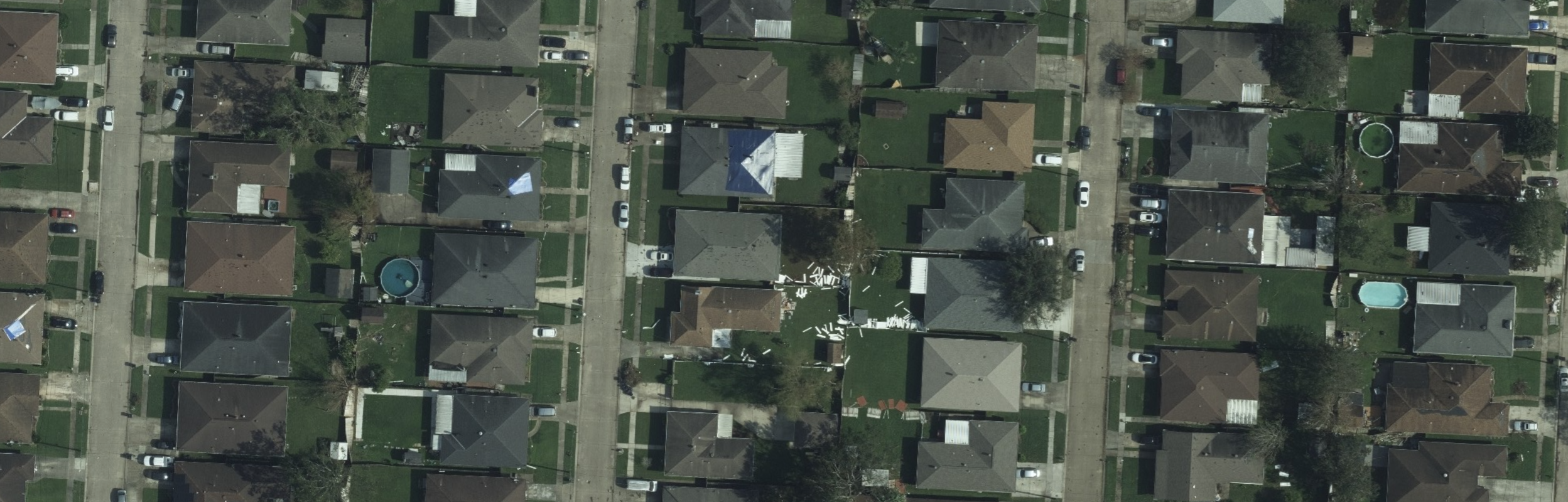
How aerial imagery speeds up Hurricane Ida claims
The aftermath of any storm is when it’s most important for us to get in contact with our clients. They’ve just gone through the trauma of a hurricane, and now they have to deal with filing claims and repairing damage. The sooner they can get that process moving, the closer they are to getting back to normal.
This is why we also send out a post-event wellness check text. That gives us a chance to check in and see how our policyholders are doing. Plus, 58 percent of these texts get a response. And if a customer indicates they’ve been evacuated, we can flag them for immediate post-storm review.
Aerial imagery is a key component of this. Vendors provide the imagery, and we leverage internal and external insights to analyze the images. If we determine one of our policyholders has a damaged roof, we don’t have to wait for the roads to clear or for internet service to come back online to get their claim started.
By using these technologies, we’re able to get claims started and processed faster for our customers. That’s our number one goal: to help our customers when they need us most.
A commitment to customers in a changing climate
The climate is changing and that means Hurricane Ida is probably not the last record-breaking storm that will affect our customers. Our focus on technology means we can handle their claims no matter what their new normal looks like.
Video Transcript
(News anchor 1): We have ominous news coming from the Hurricane Hunters as they continue to track Hurricane Ida.
(News anchor 2): The National Hurricane Center is warning that Ida will bring life-threatening storm surges, potentially catastrophic wind damage, and flooding rainfall.
(Sean Harper, Co-founder & CEO): Climate change unfortunately is actually accelerating; it's intensifying. And in a decade, there really won't be anywhere to run from it. It's the new normal and we're prepared to meet these challenges head-on while helping our customers to do the same.
(News anchor 2): The effects of Ida are already being felt, a Category 3 hurricane, winds up to 120 miles per hour as it makes landfall in Cuba.
(Angel Conlin, Chief Insurance Officer): Hurricane Ida is a reminder to all homeowners that storms can rapidly intensify into life-threatening events, so we really need to prepare. At Kin, we truly care about our customers' safety. We're here for them in the long term and in emergent situations. We work to educate our members on ways they can harden their homes to better withstand storms and other events. That's one of the reasons Kin continuously monitors catastrophic events that could reach our customers. We analyze potentially developing storms, track the path of events, and model the potential impact on our policyholders. This allows us to be there for our members when they need us most.
(Sean Harper): Technology is really important in insurance, and it's at the center of everything that we do.
(Adam Sturt, VP of Data Science): We're able to combine tons of data in near real-time to understand the impact of various events. So, for instance, when Ida was coming, we were able to take data from the National Hurricane Center and other data sources and take that layer of geospatial data and overlay it on our book of policies to understand how our policyholders might be impacted by the storm.
_(Angel Conlin): Ida's path had enough certainty that we triggered our automated pre-event text messages to all of our members in the projected path of the storm. With our pre-event texts, we proactively let our customers know the storm was coming and we provided custom resources with safety tips and ways they could prepare for the hurricane.
(News anchor 2): Hurricane Ida is forecast to be a large, powerful, dangerous hurricane, a category 4 at landfall._
(Adam Sturt): 24 hours before landfall, residents were evacuating. To help our members stay safe, we sent a second pre-event text that encouraged policyholders to download the FEMA app for weather alerts, shelter listings, and safety tips. We also continued to update our lists of customers who may be impacted by low-risk, moderate-risk, and potentially high-risk wind speeds. That allowed us to closely monitor high-risk properties for damage and customer safety.
(News anchor 2): Five hours after landfall, Hurricane Ida was still a Category 4 hurricane with sustained winds of 130 miles an hour.
(Clay Rising, VP of Claims): Ida made landfall on August 29, the 16th anniversary of Hurricane Katrina, which was the most devastating and costly hurricane in Louisiana's history. Because of Kin's use of technology and data science, our experienced claims team was well-prepared to support our customers. As soon as the storm passed, we sent wellness checks to all of our members on the path to make sure they were safe and to determine how we could help. Our policyholders texted back with insights that helped us understand the ground impact of the storm in real-time.
(Adam Sturt): If a customer notifies us that they've evacuated, we're able to flag them for immediate post-storm review using aerial imagery.
(Clay Rising): After a major event, it can take a few days to get adjusters on the ground, but because we have aerial imagery that shows a roof is damaged or not, we don't have to wait for boots on the ground to know that a home has been damaged. So we can get the process started and pay customers for damage faster. A lot of methods of communication change after a major storm ‚ there's no power, no internet, no cell phone service. So we have to adapt and contact people in any way possible and get claims started via text message because it's often the only form of communication that's working.
(Angel Conlin): By day five, we had aerial imagery available for 94 percent of our affected policyholders.
(Sean Harper): We're always keeping the customer in the loop so that they know what's happening and what they should be doing to prepare. In terms of sustained maximum wind speed at landfall, Hurricane Ida ties with Hurricane Laura and the 1856 Last Island Hurricane. These are the strongest storms on record to make landfall in Louisiana. Then it went on and it caused major flash floods throughout the Northeast, including Pennsylvania, New Jersey, and New York. This is a reminder that our climate is changing faster than ever. Storms like Ida will be the new normal. Our customers deserve an insurance company that is prepared for it.